|
Troop 24 - The High Adventure Troop
Bridger or Bust
|
|
|
Troop 24 - The High Adventure Troop
Bridger or Bust
|
Even though the sun was shining as we cooked breakfast, we could see black clouds in the west. When the storm hit, we looked for shelter where we could find it - above timberline as we were this was a little more difficult than it had been in previous days. Fortunately there were a lot of house sized boulders ringing our camp and a lot of these had overhanging ledges which provided shelter. A few of the more intrepid souls even found a "cave" under one of them and proceeded to wriggle out of sight.
Danny found an old dutch oven under a rock. Who knows how long it had been there? I wondered if the last users had stashed it under there fully expecting to come back some time for it, and if age or infirmity, or changed circumstance prevented their return. It had obviously been hid with the intention of being retrieved someday. Since we had six more days to go no one wanted to carry it out for a souvenior, so we put it back under the rock for some one else to find and wonder about.
Leaving Bridger Lake #3
Bill M, Jason, Bill P., Jon, Peter, Kyle,
|
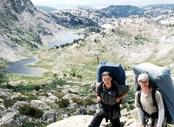
It looked old fashioned somehow, and different from modern dutch ovens. There had been an old overgrown firepit near the spot and one of the boys found an old horseshoe almost completely buried. In 1988, we had seen old dried horse turds on the other side of the lake but not on this trip. Cowboys had come in here at one time but not recently. After the brief storm, we finished packing up and got ready to take off. Before we left we all lined up for the picture above. Because of rocks near the lake, we headed to the left near the slope of the mountain above. As we went over a little rise, we could see the vague outlines of an old trail that was now mostly grown over and as all discoverers we felt good. Descending a rocky shoulder on the old trail we come to grassy meadows on the north side of the lake where the old tread disappears again. We just keep going around the lake, passing the camp spot we had used in 1988 and head for the draw through which the stream coming down from Bridger Lake #4 above comes through. |
|
Coming out of the draw, we enter a wide basin and we can see the Bridger Lake #4 ahead of us. It is much smaller than any of the others. There are no trees or large boulders anywhere around it. We could see fish jumping in it as well.
We had had some bragging about who was the top hiker so we had decided to have a contest should a suitable spot present itself. Just beyond the lake a steep open slope stretched up to a pass above. In the middle of the hill above there was a large rock which was chosen to be the objective for the Troop 24 Hill Climb Challenge.
The rules were simple: contestants would start in order of age with youngest going first. The next oldest group would depart 30 seconds after the preceding group. I stayed behind and counted off the starting times. Roger as the youngest was first out of the gate. The remaining boys took off in their appointed groups.
Bridger Lakes #4, #3, & #2 Below |
Roger took off like a demon and it didn't look like anyone was making time on him. Soon they were all like ants above me and I lost track of who was in the lead. When I made it up to the rock, I was told that Jason, Roger, Brian, and Cary had gotten their first. I told them that they would get more weight tomorrow. At the bottom it looked like the rock was a the top of the pass but, when you got there the pass was still a couple of hundred yards away. We lugged our packs to the pass for a short break. On the other side of the pass we could see the valley that the Sauerkraut Lakes are in but we couldn't see the lakes themselves. I told Bill, Jason, and Brian to walk up the ridge to see if there was a trail. They all yelled that there was one, but all three were going in different directions. Lacking a trail I headed the group up the ridge on a slanting climbing traverse towards the southeast. It was a scramble but not overly difficult, even for a F.O.M. |
Guiterrez Peak (11362') /Bridger Lakes |
Near the top of the ridge there is a ledge with a terrific view of the way we had come. We took off our packs and rested. We felt good that our climb was just about over and seeing how far we had come. From below it looked as if our viewpoint was the top but when we got there we saw that there was still a short climb ahead. We headed to an obvious notch and although the last bit was very steep, we were over it in a flash. On the other side of the ridge the majestic peaks of the continental divide come into view, an inspiring sight. Just below the ridge is a small pond, we descend and take off our packs for lunch. |
|
Just above the pond is an old trail coming up from below. My son Greg and I had discovered this trail by chance in 1988. It looked like it hadn't been used in the interim. Since we had a trail I put Jason in front per our usual order and we took off. He promptly headed over a saddle back towards the basin we just had left. A golden eagle glided up from below just in front of us. I'm sure he was very surprised to see our group. He quickly glided out of sight, and very few of the boys saw him. I yelled to Jason to stop and went back up to the front to lead the group. I showed him where the trail went off to the left and down some switchbacks to a wide boulder strewn meadow. |
|
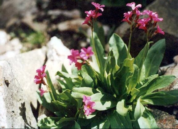
Going down the switchbacks we come upon some pretty purple flowers growing among the rocks at the side of the trail. Remembering that Brian had expressed a desire to get some photographs of flowers for his mother, I called a halt for a "Kodak" moment. The boys in the back started kidding Brian about this and he said he would pass. Jason pulled out his camera and got the photo above.

|
In the meadow, the trail was a little easier to follow so I went back to the rear and we continued on our way. According to the map we were following down the stream from the small lake at the top of the ridge at which we had eaten lunch. We crossed it several times on the way down.
Fremont Peak/Continental Divide Peaks Beyond |
When the trail swings close to the stream again, the scene shown in the photo above unfolds - a beautiful lake below and Mt. Fremont beyond. Because of the steep hill, the stream roars its way down making it a perfect place to fill one's canteens and ponder who made the trail we are on and when was it built. It didn't appear to have been travelled at all, and is slowly receding back to nature. Leaving the stream, the trail traverses and then dips with a series of switchbacks coming out just to the south of the small lake (seen above). It was at this point that we had found the trail in 1988 having followed up the stream from Moya Canyon. The old trail turns south at the lake and drops down through a rocky basin and comes in a meadow where the tread is lost.
|
From here to Moya Canyon the old tread is very vague and you can only find it in the obvious places. But the route is easy and you just keep dropping until you are in the canyon itself. When you are close to the stream, look for the crossing point near where you can see a long flat basin to the south. Cross the stream and follow it down until the tread becomes visible again. Near the end of a flat meadow, the trail heads up the side of the hill to the left (east) and after a short climb, begins a long descent to Lost Lake.
|
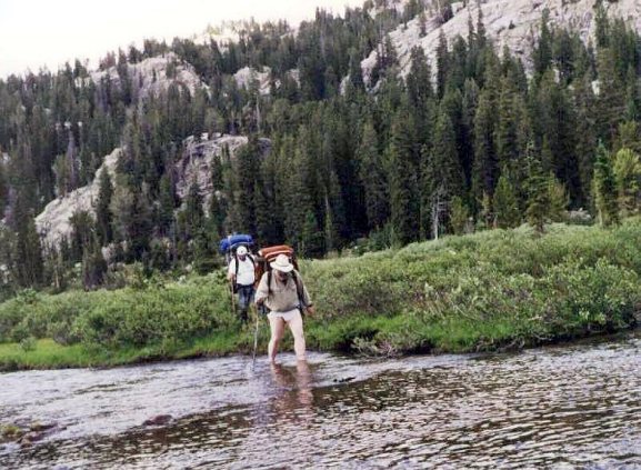
After a big bend in the trail, we came out at the Fremont River just as it flows into Lost Lake. I had planned to camp on this side of the river and do the ford in the morning but just as we were discussing our options, two hikers came out of the woods and asked where you were supposed to cross the river. They had been having trouble and had tried to cross up stream by jumping across on rocks but one of their group had taken a bad fall in the river and hit his head and skinned himself up pretty badly. There were four of them and I guess had had an argument after this and were splitting up into two groups of two. I told them that you just waded across right in front of us where the water was flowing slowly and about knee high and that there was another ford just ahead about the same. I also told them that it was very easy and that the trail up to Senaca Lake takes off to the left of the campsite on the other side of the lake. They easily made it across. |
After they had made it across, the other two members of their group came up from the nearby campsite. The one guy was looking pretty dazed and his legs were very badly scratched up. I gave them some Neosporin for his wounds and asked if they needed any medication. "No thanks, we have some Jack Daniels" was the reply.
Since they were using the campsite, we decided to ford the river and camp on the other side. Bill P. speculated that the four hikers were from back east somewhere, having probably gone to school together. He thought that one of them must have read an article about backpacking in the Wind Rivers and convinced the others to go. Now they weren't even speaking to each other and they still had the better part of a week to go.
Of Fremont River At Lost Lake |
The options were to cross in your boots, go barefoot, use your camp shoes, or a wool sock. Nobody wanted to get their boots wet so some went barefoot, some put on their tennis shoes and some just put on a dirty pair of wool socks. It was a new experience for just about everyone and we all had a lot of laughs going across. Because the water was knee deep, I didn't want to get my pants wet so I took them off and crossed in my underwear. Charlie and I were bringing up the rear so when we crossed the second time, cries of "Naked Old Man" came from the boys. When I got into camp, the two hapless hikers were wandering around the camp looking for the trail. Still in my underwear, I pointed out where the trail was and they took off, hopefully for better times. The lesson here is plain. It doesn't hurt to get your feet wet but you can get hurt by taking unnecessary risks to keep them dry. Those guys were lucky that someone had not gotten seriously hurt or worse. |
|
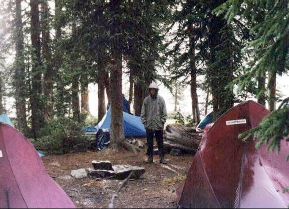
As we set up camp it got really dark and we had another Wyoming Thunderstom. It poured for a few moments and stopped as suddenly as it had begun. As the skies cleared, we had a huge double rainbow take shape. We hoped that it would be a harbinger of better weather to come.

|
Some of the group got out their fishing tackle and tried their luck. Others hunted for firewood which was very scarce near the campsite. Our big group made it easy to gather enough for a big campfire after supper. A good arrangement of sitting logs made for an enjoyable discussion around the fire. Sometimes we could see the glow from the fire across the lake where two of the hapless hikers were staying. We wondered how much of the Jack Daniels was left.