|
Troop 24 Kickass Trekkers
|
|
|
Troop 24 Kickass Trekkers
|
|
|
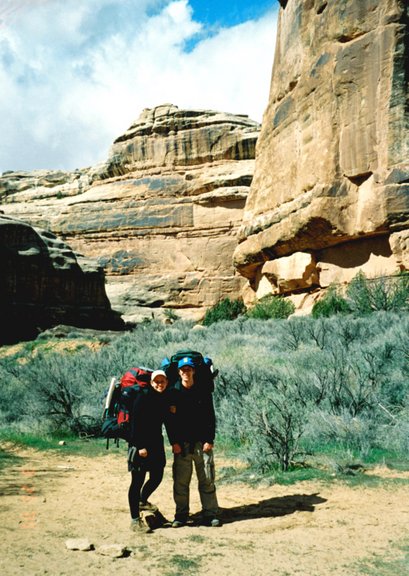
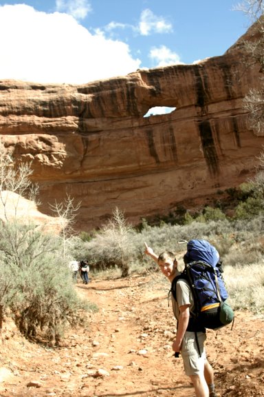
Grand Gulch
|
We had a rough time getting to the Government Trail trailhead the previous night. There had been a snowstorm on Cedar Mesa and after it melted, the road was a gooey mess. I gunned my Corolla but only made it about a hundred yards from the paved road before getting stuck. The guys were able to push it back to the main road. Our other vehicle was an old Cadillac sedan with 2WD but we had the advantage of a crazy driver (Shelby). So we packed what gear we could into it and Shelby, Roger, Dan, Allison took off. Eric and I wated to see if they would make it back for the second triop. About 45 minutes later the Caddy roared back. After packing the rest of the gear in, we shuttled the Corolla back to the Kane Gulch Ranger Station. What followed next was the wildest ride of my life. What we lacked in traction we had to make up for with speed.
So off we went, with Hip Hop Rap blaring from the speakers, we tore down the road sashshaying back and forth as we tore through the mud and large pools of water covering the road. Somehow, we made it to about a couple of hundred yards from the trailhead, stopping only when the bedrock threatened the undercarriage. We packed our gear to the trailhead and made camp for the night.
|
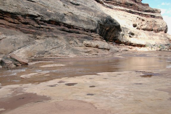
Day 1:Looking down from the rim of the Gulch, there was something we didn't expect to see - a river. While there was a trickle from Polly's Canyon in 2000 that soon dried up, it had been bone dry in 2002. Above Polly's Canyon the water flow in the Gulch made travel much more difficult than in a normal year. As this section is almost always dry, you usually hike in the wash so no trails are made through the brush on either side of the wash. You had a difficult choice to make - Wade or fight through very tough brush. After a long day sloshing up the Gulch we made camp at the mouth of Dripping Canyon. The camp is located in a grove of cottonwoods at the junction of the Gulch and Dripping Canyon. In 2002 we camped here but had a long trek up Dripping Canyon to find a stagnant pool for water but not this year as there was a stream coming down the gulch right below the camp. |
Day 2:You had a choice - wade thru the muck or beat the brush. Neither was very good. The stretch from Polly's Island to Step Canyon was pretty rough. This was our third trip along this stretch as we had come down the Gulch in 2000 and we were retracing our route from 2002. Above Step Canyon there was no more wading but you had to cross the wash (creek) frequently. These crossing were difficult because of the steepness of the bank and the depth of the water. Long Legged Danny could jump across with ease but I usually ended up with both feet in the water and my knees covered in muck! Along this stretch, the canyon has become clogged with the alien Tamarisk plant - the scourge of the southwest - which has forced out many native plants. |
|
|
Day 3:We spent our second night at the confluence of Bullet Canyon and Grand Gulch. Camps here are hard to come by because of the number of parties and ours was a pretty mediocre spot. There was a rain shower just before we got up, so getting going was slower than usual. After the first couple of days, the travelling is much easier above the Bullet/GG junction - although there was still water in the wash, but for the most part the wider canyon and heavier traffic provided more developed foottrails which made for much easier going. I did have one mishap though, as I was following a trail (the wrong one apparently), I stepped on a low branch that broke and before I knew it I was rolling down the steep bank and ended up in the creek. Luckilly, I was able to extricate myself from the mud with only wet clothes and bruised dignity. During the day there were intermittent periods of rain and sunshine. We made sidetrips to the Green Mask Panel and Split Level Ruin, and had a little chuckle while passing the mouth of Coyote Canyon remembering Fred chewing out Steve and Braxton in 2002. As in 2002, we made our camp on a bench above the Pouroff Pool. |
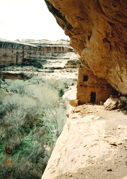
Day 4:After breakfast, we said our Goodbyes to Shelby and Roger as they were hiking out to the car (Kane Gulch) so they could attend the Lebowskifest in Los Angeles. We broke camp soon after, making our way up canyon past Todie Canyon. We took some time to explore Turkey Pen Ruin - a really impressive collection of ruins and pictograph panels just down canyon from the Junction with Kane Gulch. We reached our destination early in the afternoon, and made camp at the Junction in a magnificent grove of cottonwoods. While Dan, Eric, and Allison spent the afternoon in camp, I hiked up the Gulch to take in more of the spectacular scenery. We were up and on our way just as there was enough light to see. After a trek up Kane Gulch (water flowing all the way up), we found the Corolla safe and sound in the ranger station parking lot. I had been a little worried as Shelby and Roger had to go back down the road to the Gov't Trail to get their car. Later they told us that the road had dried enough so that there was no trouble getting back down it. |
Just Down Canyon from Turkey Pen Ruin |
|
|
Anaconda-Pintler Wilderness
|
Day 2:From our camp on the NW shore of Carpp Lake we head west along the Hiline Trail climbing a couple of hundred feet over a ridge and then dropping down to Tamarack Creek. A few switchbacks past the creek crossing the astute observer can see the faint tread of the old Tamarack Lake Trail (1.8 mi from Carpp Lake), we had gone by yesterday coming up the hill. Turning south, the trail climbs through open forest to a trail junction where the Hiline Trail turns west and the Tamarack Lake trail continues South. (2.4 mi from Carpp Lake). After a short distance, a small lake is seen through the trees (Little Annie Lake). Past the lake the trail starts climbing seriously, finally breaking out in meadows and trending downhill (you think you're finally there), but the trail (which is not as shown on the topo map, heads up again, finally rounding a small pond (not shown on the map) before arriving at beautiful Tamarack Lake (3.6 mi and about 1100' elev gain from Carpp Lake). After a short hiking day - Time to Relax. Nothing finer than sitting in your lawn chair out in the lake. Shelby got a 16 inch cutthroat trout on his second cast - no further action at all. We (well I did) filleted the fish and cooked it, but the flesh was very soft and we ended up burying most of it. I would rather eat a passle of 8-10 inchers any day, although the large rainbows we caught in Idaho were really good. |
|
|
Day 3:From Tamarack Lake we retrace our route down to the Hiline Trail where we head west over a small hill and down to cross the creek coming down from Tamarack Lake. After crossing the creek, the trail climbs steeply up to cross Porter Ridge (2 mi and 400' elev gain from Tamarack Lk). After crossing the ridgeline, the trail trends up for a while before trending down for a long traverse through trees, meadows and a talus slope. Reaching another ridge, the trail switchbacks down to join the Falls Fork of Rock Creek drainage passing along the way the side trail to Edith Lake (not as shown on topo but much higher up). After the junction, the Hiline Trail passes through a large burn area - Not Much Fun hiking - that on a hot day would be pure hell. Fortunately, at the upper end of the valley, the trail leaves the burn area to enter the cool forest for the final switchbacks up over the ridge to Johnson Lake. Before reaching the lake, the Burn area is entered again and a trail sign and map outlining camping restrictions directs you to camps on either side of the lake. As the burn area is on the east shore we take the main trail along the west shore, camping at a nice camp at the south end of the lake. |
Day 4:Following the spur trail between the Hi Line Tr and the Continental Divide Tr, we then head south on the Continental Divide Trail through forest then more steeply via switchbacks to a meadowed basin below Pintler Pass. After a break we follow the trail to the end of the basin then up more switchbacks to grassy Pintler Pass (Elev 8740' - about 2 mi from Johnson Lake). Dropping down quickly we traverse to the jct of the Oreamnos Lake Trail (High Route). From there it is a short climb to Oreamnos Lake (EL 8363') where we set up camp - 3.2 miles and 1350' total elev gain from Johnson Lake. Just after we got to our camp at Oreamnos Lake, a thunderstorm hit and we sat under the evergreens and waited out the storm. When the rain abated we tried our luck fishing in Oreamnos with no strikes. There were fish in the lake but they were'nt biting. I hiked up to the upper lake and tried a few casts but no luck there either. |
|
|
Day 5:Originally, I had planned to retrace our steps back to the Cont Divide Tr and follow it, but when exploring the basin above Oreamnos Lk, I found vague tread from an old abandoned sheep drive heading over a pass towards Sawed Cabin Lake. We decided to follow this tread - if it panned out, we could save a lot of distance and climbing. Pan out it did and we were able to cut out a couple of miles and about a 1000' feet of climb. Rejoining the Cont. Divide Tr above Sawed Cabin Lake, we followed it to pick up the trail towards Bitterroot Pass to Kelly Lake for Camp 5 (6.3 miles and 1450' of elev gain from Oreamnos Lake). The only fly in the ointment was a steep hill above Oreamnos Lake, and I was sure breathing hard when I got to the top. It was almost as steep as Hell Hill in the Payseyton (see 2001 trips). All in all, this was the best day of the year for me - finding another abandoned sheep drive is always the best. |
Day 6:When we rolled out of our sleeping bags, it was still dark and everything was covered with a thick layer of frost. Because of our long hike we fixed our oatmeal breakfast while packing up and were on our way before the sun was over the ridge. The climb to Bitterroot Pass from Kelly Lake is not far (a little less than a mile and about 400' climb) but there is a maddening false summit near the top where you think that you're there but then you start going up again. Over the top and down to Little Johnson Lake (1.4 mi) . Then a minor up to a shoulder then dropping to a basin, crossing to another shoulder then dropping down to a major meadow (nice camp - we had intended to stay here for Camp 6 after staying at Hidden Lake for Camp 5, but we opted to get out a day early. At the end of the meadow is the junction with the Middle Fork trail (2.5 mi from Kelly Lk). From there it's 4.1 miles of valley pounding to the trailhead.
|
|
Granite Ghost Town - MontanaAugust 2005
Click on Photo
|